Beautiful Highway 89 North from Truckee, CA. We left Truckee searching for beautiful fall colors and new destinations for us. Driving north towards Hobart Mills, thru the small cattle town of Sierraville, on to Graeale a golfers retreat, Quincy and Keddie. We had been this far in the past.

We continued on to Lake Almanor. A large lake with many access points and looks like it will require a return visit for kayaking next spring.

Lake Almanor near the dam. A much larger lake than we expected.
Onward on Hwy 89, to the Scenic Volcano Legacy highway which leads into and out of Lassen Volcano National Park.

Starting at the Kohm Yah-mah-nee Visitors Center we oriented ourselves and set out to explore the park.

First stop, ‘Sulphur Works’ to see the boiling mud pots which were very close to the road. Prior to the 1952 purchase of this area from the Supan family it had been a bathhouse and dining hall since 1865.


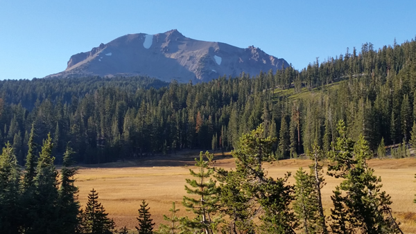
We had a picnic at Lake Helen which is at the base of Lassen Peak.


Next stop was the Bumpass Hell parking area, overlook and trailhead. The trail is about 1.5 miles down to a great boardwalk thru the geothermal area. Then, be prepared for 1.5 miles back up, but well worth the hike. You may notice the altitude as the trail starts at 8,000 feet.


We stopped at various view points on the 32 mile road thru the park.


Our last areas were called ‘Devastated Area’ and ‘Chaos Crags’ and ‘Jumbles’ which helped to show the power of the volcanic eruptions in the 1800’s and 1914!


A beautiful park which definitely needs more exploration and hiking. We didn’t realize that we could have downloaded an audio guide to all the points of interest before we went to the park. Most of the part did not have cell service. Go here to download the audio guide to your phone before going to Lassen Volcano National Park.
We continued north on Hwy 89 along the beautiful Hat Creek and it’s watershed area. We turned onto Hwy 299 to spend the night at Burney, CA before we will continue north on Hwy 89.
Mostly an RV town with a few hotels. We stayed at the Charms Motor Lodge which was basic but clean, remodeled and good for the night. Tomorrow, we visit Burney Falls.

8 responses to “Fall Roadtrip..Hwy 89 North”
[…] Start Hyw 89 series | Start Peru series | Start Galapagos series | Start Remodel series | […]
[…] First Post in this series | Start Peru series | Start Galapagos series | Start Remodel series | […]
[…] First Post in this series | First Post in Peru series | First post in Galapagos series […]
My Dear Vicki, You should consider publishing a tour guide book. You do such an awesome job. I feel I’m on the trip with you from the descriptions and pictures you share. Traveling vicariously with you and Bob is almost as good as doing it myself. You certainly ly have given me some great ideas.
I did get to go camping a few years ago at Burney Falls with my daughter and family. It was very enjoyable even though I was only there for one night. Enrique and I shared a lil cabin. Looking forward to seeing you and Bob soon. Hugs to you both. Sent from my Verizon Wireless 4G LTE smartphone
Thanks so much. I love ‘arm chair’ travel and try to write as though someone might be interested in doing the same areas.
[…] First Post in this series | First Post in Peru series | First post in Galapagos series […]
Great Photos of the area. It is beautiful, just like I remember it. The first time I was there was in the 60’s. I camped in a tent. It was so cold at night and I could not get warm. The last time I was there was in the 80’s when I flew in with friends in a private plane to their vacation home. There are more trees around the Lassen area than I remember and less water in the lake. The area goes on for miles and miles. Enjoy!
Nice!